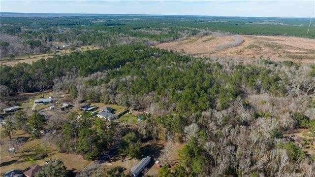
Phillip Corry Road Starks, LA 70661
Other Residential
MLS #: SWL23000877
Courtesy Of Flavin Realty Inc
Property InformationDescription
Approximately 20 acres of land located in Starks. Flood zone X and AE according to Fema flood maps. All measurements are M/L. Drive by to view.
Features
- Architecture Style: Other
- Lot Size: 20 Acres
- Roof Type: Unknown
VIDEOS AND TOURS
MAP & DIRECTIONS
School Information
Phillip Corry Road, Starks, LA 70661
Elementary School
Grades PK-12 |
Public School
STARKS HIGH SCHOOL
Starks, LA 70661
137 Highway 10P S
337.217.4820
Distance: 0.6 mi
School Rating
C+
Student:Teacher Ratio
9:1
Total Students
299
Middle School
Grades PK-12 |
Public School
STARKS HIGH SCHOOL
Starks, LA 70661
137 Highway 10P S
337.217.4820
Distance: 0.6 mi
School Rating
C+
Student:Teacher Ratio
9:1
Total Students
299
High School
Grades PK-12 |
Public School
STARKS HIGH SCHOOL
Starks, LA 70661
137 Highway 10P S
337.217.4820
Distance: 0.6 mi
School Rating
C+
Student:Teacher Ratio
9:1
Total Students
299
Demographic Data
Starks, LA 70661
| Median Age: | 47.6 |
|---|---|
| Married: | 47% |
| Number of Households: | 750 |
| Households with Children: | 20.8% |
Starks, LA 70661
Demographic Data
-
Occupancy Types
- 0 Vacant
- 0 Owned
- 0 Rented
-
Transportation to Work
- 0 Drive
- 0 Public Transportation
- 0 Walk / Bike / Other
- 0 Work at Home
Copyright © 2024 Greater Southern MLS. All rights reserved. All information provided by the listing agent/broker is deemed reliable but is not guaranteed and should be independently verified. Information being provided is for consumers' personal, non-commercial use and may not be used for any purpose other than to identify prospective properties consumers may be interested in purchasing.
